|
| at: |
Francis Marion National Forest |
Data from USFS GIS
 show on map
 animate
Trail users:


Elevation Profile
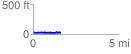
 1.632220 mi
 139.25 ft
 142.87 ft
 -3.63 ft
 1.66 %
GPX Downloads: Track Route
![]()
|
| at: |
Francis Marion National Forest |
show on map
animate
1.632220 mi
139.25 ft
142.87 ft
-3.63 ft
1.66 %