|
| at: |
Francis Marion National Forest |
Data from USFS GIS
 show on map
 animate
Trail users:


Elevation Profile
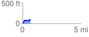
 0.667281 mi
 100.38 ft
 33.96 ft
 66.42 ft
 2.85 %
GPX Downloads: Track Route
![]()
|
| at: |
Francis Marion National Forest |
show on map
animate
0.667281 mi
100.38 ft
33.96 ft
66.42 ft
2.85 %