|
| at: |
Francis Marion National Forest |
Data from USFS GIS
 show on map
 animate
Trail users:


Elevation Profile
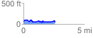
 2.598534 mi
 232.37 ft
 223.74 ft
 8.63 ft
 1.69 %
GPX Downloads: Track Route
![]()
|
| at: |
Francis Marion National Forest |
show on map
animate
2.598534 mi
232.37 ft
223.74 ft
8.63 ft
1.69 %