|
| at: |
Sumter National Forest - Andrew Pickens District |
Data from USFS GIS
 show on map
 animate
Trail users:


Elevation Profile
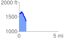
 0.903096 mi
 110.64 ft
 390.85 ft
 -280.20 ft
 8.20 %
GPX Downloads: Track Route
![]()
|
| at: |
Sumter National Forest - Andrew Pickens District |
show on map
animate
0.903096 mi
110.64 ft
390.85 ft
-280.20 ft
8.20 %