|
| at: |
Sumter National Forest - Andrew Pickens District |
Data from USFS GIS
 show on map
 animate
Trail users:


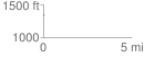
Elevation Profile
 0.033426 mi
 5.72 ft
 5.04 ft
 0.68 ft
 3.24 %
GPX Downloads: Track Route
![]()
|
| at: |
Sumter National Forest - Andrew Pickens District |
show on map
animate
0.033426 mi
5.72 ft
5.04 ft
0.68 ft
3.24 %