| at: |
Sumter National Forest - Andrew Pickens District Rocky Gap Horse Trail |
Data from USFS GIS
 show on map
 animate
Trail users:


Elevation Profile
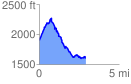
 2.969660 mi
 686.75 ft
 949.53 ft
 -262.78 ft
 6.06 %
GPX Downloads: Track Route
![]()
| at: |
Sumter National Forest - Andrew Pickens District Rocky Gap Horse Trail |
show on map
animate
2.969660 mi
686.75 ft
949.53 ft
-262.78 ft
6.06 %