| at: |
Sumter National Forest - Andrew Pickens District Rocky Gap Horse Trail |
Data from USFS GIS
 show on map
 animate
Trail users:


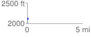
Elevation Profile
 0.066687 mi
 15.47 ft
 39.59 ft
 -24.12 ft
 11.24 %
GPX Downloads: Track Route
![]()
| at: |
Sumter National Forest - Andrew Pickens District Rocky Gap Horse Trail |
show on map
animate
0.066687 mi
15.47 ft
39.59 ft
-24.12 ft
11.24 %