| at: |
Sumter National Forest - Andrew Pickens District Rocky Gap Horse Trail |
Data from USFS GIS
 show on map
 animate
Trail users:


Elevation Profile
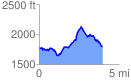
 4.042455 mi
 963.13 ft
 963.13 ft
 0.00 ft
 4.51 %
GPX Downloads: Track Route
![]()
| at: |
Sumter National Forest - Andrew Pickens District Rocky Gap Horse Trail |
show on map
animate
4.042455 mi
963.13 ft
963.13 ft
0.00 ft
4.51 %