| at: |
Sumter National Forest - Andrew Pickens District Rocky Gap Horse Trail |
Data from USFS GIS
 show on map
 animate
Trail users:


Elevation Profile
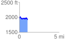
 1.022834 mi
 289.04 ft
 345.54 ft
 -56.50 ft
 6.40 %
GPX Downloads: Track Route
![]()
| at: |
Sumter National Forest - Andrew Pickens District Rocky Gap Horse Trail |
show on map
animate
1.022834 mi
289.04 ft
345.54 ft
-56.50 ft
6.40 %