| at: |
Sumter National Forest - Andrew Pickens District Rocky Gap Horse Trail |
Data from USFS GIS
 show on map
 animate
Trail users:


Elevation Profile
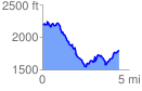
 4.479436 mi
 1140.71 ft
 1555.50 ft
 -414.79 ft
 6.58 %
GPX Downloads: Track Route
![]()
| at: |
Sumter National Forest - Andrew Pickens District Rocky Gap Horse Trail |
show on map
animate
4.479436 mi
1140.71 ft
1555.50 ft
-414.79 ft
6.58 %