| at: |
Wolf Creek Area |
Data from USFS GIS
 show on map
 animate
Trail users:

Elevation Profile
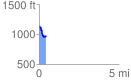
 0.422621 mi
 44.56 ft
 240.24 ft
 -195.68 ft
 10.77 %
GPX Downloads: Track Route
![]()
| at: |
Wolf Creek Area |
show on map
animate
0.422621 mi
44.56 ft
240.24 ft
-195.68 ft
10.77 %