| at: |
Sumter National Forest - Long Cane District Cedar Springs OHV Trail |
Data from USFS GIS
 show on map
 animate
Trail users:


Elevation Profile
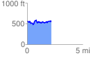
 2.193183 mi
 406.53 ft
 406.53 ft
 0.00 ft
 3.51 %
GPX Downloads: Track Route
![]()
| at: |
Sumter National Forest - Long Cane District Cedar Springs OHV Trail |
show on map
animate
2.193183 mi
406.53 ft
406.53 ft
0.00 ft
3.51 %