| at: |
Sumter National Forest - Long Cane District Parsons Mountain Lake Recreation Area |
Data from USFS GIS
 show on map
 animate
Trail users:


Elevation Profile
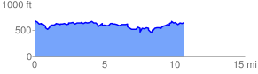
 10.877778 mi
 2880.59 ft
 2880.59 ft
 0.00 ft
 5.02 %
GPX Downloads: Track Route
Trailheads:
 Parsons Mountain OHV Trailhead