| at: |
Sumter National Forest - Long Cane District Cedar Springs OHV Trail |
Data from USFS GIS
 show on map
 animate
Trail users:


Elevation Profile
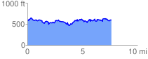
 7.843938 mi
 1912.74 ft
 1912.74 ft
 0.00 ft
 4.62 %
GPX Downloads: Track Route
Trailheads:
 Cedar Springs OHV Trailhead