| at: |
Sumter National Forest - Long Cane District Parsons Mountain Lake Recreation Area |
Data from USFS GIS
 show on map
 animate
Trail users:

Elevation Profile
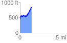
 1.444406 mi
 590.84 ft
 218.37 ft
 372.47 ft
 7.75 %
GPX Downloads: Track Route