| at: |
Amicalola/Nimblewill/Tickanetley |
Data from David Muse
 show on map
 animate
Trail users:

Elevation Profile
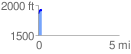
 0.212815 mi
 89.10 ft
 16.80 ft
 72.30 ft
 7.93 %
GPX Downloads: Track Route
![]()
| at: |
Amicalola/Nimblewill/Tickanetley |
show on map
animate
0.212815 mi
89.10 ft
16.80 ft
72.30 ft
7.93 %