| at: |
Bonnet Carre Spillway |
Data from David Muse
 show on map
 animate
Trail users:


Elevation Profile
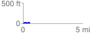
 0.588143 mi
 50.52 ft
 48.55 ft
 1.97 ft
 1.63 %
GPX Downloads: Track Route
![]()
| at: |
Bonnet Carre Spillway |
show on map
animate
0.588143 mi
50.52 ft
48.55 ft
1.97 ft
1.63 %