| at: |
Bonnet Carre Spillway |
Data from David Muse
 show on map
 animate
Trail users:


Elevation Profile
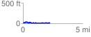
 2.260225 mi
 133.20 ft
 151.90 ft
 -18.70 ft
 1.27 %
GPX Downloads: Track Route
![]()
| at: |
Bonnet Carre Spillway |
show on map
animate
2.260225 mi
133.20 ft
151.90 ft
-18.70 ft
1.27 %