| at: |
Bonnet Carre Spillway |
Data from David Muse
 show on map
 animate
Trail users:


Elevation Profile
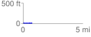
 0.750848 mi
 30.51 ft
 51.84 ft
 -21.33 ft
 1.31 %
GPX Downloads: Track Route
![]()
| at: |
Bonnet Carre Spillway |
show on map
animate
0.750848 mi
30.51 ft
51.84 ft
-21.33 ft
1.31 %