| at: |
Levee Bike Path (Baton Rouge Area) |
Data from David Muse
 show on map
 animate
Trail users:


Elevation Profile
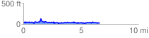
 6.689554 mi
 655.20 ft
 672.92 ft
 -17.72 ft
 1.91 %
GPX Downloads: Track Route
![]()
| at: |
Levee Bike Path (Baton Rouge Area) |
show on map
animate
6.689554 mi
655.20 ft
672.92 ft
-17.72 ft
1.91 %