| at: |
Levee Bike Path (St. Gabriel Area) |
Data from David Muse
 show on map
 animate
Trail users:


Elevation Profile
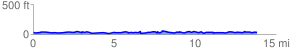
 13.988715 mi
 1323.84 ft
 1324.17 ft
 -0.33 ft
 1.79 %
GPX Downloads: Track Route
![]()
| at: |
Levee Bike Path (St. Gabriel Area) |
show on map
animate
13.988715 mi
1323.84 ft
1324.17 ft
-0.33 ft
1.79 %