| at: |
Levee Bike Path (Baton Rouge Area) |
Data from David Muse
 show on map
 animate
Trail users:


Elevation Profile
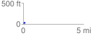
 0.152732 mi
 21.66 ft
 0.00 ft
 21.66 ft
 2.69 %
GPX Downloads: Track Route
![]()
| at: |
Levee Bike Path (Baton Rouge Area) |
show on map
animate
0.152732 mi
21.66 ft
0.00 ft
21.66 ft
2.69 %