| at: |
Coopers Furnace Day Use Area |
Data from David Muse
 show on map
 animate
Trail users:

Elevation Profile
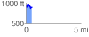
 0.487904 mi
 165.35 ft
 176.83 ft
 -11.48 ft
 6.86 %
GPX Downloads: Track Route
Trailheads:
 Laurel Ridge Trail Lot
![]()
| at: |
Coopers Furnace Day Use Area |
show on map
animate
0.487904 mi
165.35 ft
176.83 ft
-11.48 ft
6.86 %
Laurel Ridge Trail Lot