| at: |
Lost Mountain Park |
Data from David Muse
 show on map
 animate
Trail users:


Elevation Profile
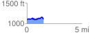
 1.520248 mi
 194.55 ft
 171.91 ft
 22.64 ft
 2.42 %
GPX Downloads: Track Route
Trailheads:
 Lost Mountain Park Pond Lot
![]()
| at: |
Lost Mountain Park |
show on map
animate
1.520248 mi
194.55 ft
171.91 ft
22.64 ft
2.42 %
Lost Mountain Park Pond Lot