| at: |
North Mills River Recreation Area Davidson River Area |
Data from David Muse
 show on map
 animate
Trail users:


Elevation Profile
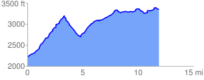
 12.029480 mi
 2042.11 ft
 932.83 ft
 1109.28 ft
 3.22 %
GPX Downloads: Track Route
![]()
| at: |
North Mills River Recreation Area Davidson River Area |
show on map
animate
12.029480 mi
2042.11 ft
932.83 ft
1109.28 ft
3.22 %