| at: |
North Mills River Recreation Area |
Data from David Muse
 show on map
 animate
Trail users:


Elevation Profile
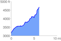
 6.217598 mi
 1729.75 ft
 178.91 ft
 1550.85 ft
 5.27 %
GPX Downloads: Track Route
![]()
| at: |
North Mills River Recreation Area |
show on map
animate
6.217598 mi
1729.75 ft
178.91 ft
1550.85 ft
5.27 %