| at: |
Davidson River Area |
Data from David Muse
 show on map
 animate
Trail users:


Elevation Profile
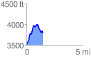
 1.478014 mi
 590.62 ft
 298.52 ft
 292.10 ft
 7.57 %
GPX Downloads: Track Route
![]()
| at: |
Davidson River Area |
show on map
animate
1.478014 mi
590.62 ft
298.52 ft
292.10 ft
7.57 %