| at: |
Atlanta Beltline |
Data from David Muse
 show on map
 animate
Trail users:


Elevation Profile
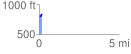
 0.198955 mi
 35.73 ft
 10.10 ft
 25.62 ft
 3.40 %
GPX Downloads: Track Route
![]()
| at: |
Atlanta Beltline |
show on map
animate
0.198955 mi
35.73 ft
10.10 ft
25.62 ft
3.40 %