| at: |
Burnt Mountain |
Data from David Muse
 show on map
 animate
Trail users:


Elevation Profile
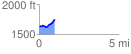
 0.980304 mi
 170.80 ft
 43.83 ft
 126.97 ft
 3.30 %
GPX Downloads: Track Route
![]()
| at: |
Burnt Mountain |
show on map
animate
0.980304 mi
170.80 ft
43.83 ft
126.97 ft
3.30 %