| at: |
Burnt Mountain |
Data from David Muse
 show on map
 animate
Trail users:


Elevation Profile
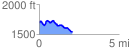
 2.080698 mi
 173.85 ft
 316.50 ft
 -142.65 ft
 2.88 %
GPX Downloads: Track Route
![]()
| at: |
Burnt Mountain |
show on map
animate
2.080698 mi
173.85 ft
316.50 ft
-142.65 ft
2.88 %