| at: |
Burnt Mountain |
Data from David Muse
 show on map
 animate
Trail users:


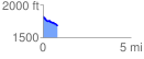
Elevation Profile
 0.833271 mi
 36.58 ft
 153.51 ft
 -116.93 ft
 3.49 %
GPX Downloads: Track Route
![]()
| at: |
Burnt Mountain |
show on map
animate
0.833271 mi
36.58 ft
153.51 ft
-116.93 ft
3.49 %