| at: |
Burnt Mountain |
Data from David Muse
 show on map
 animate
Trail users:


Elevation Profile
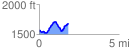
 1.838192 mi
 343.83 ft
 237.96 ft
 105.87 ft
 3.54 %
GPX Downloads: Track Route
![]()
| at: |
Burnt Mountain |
show on map
animate
1.838192 mi
343.83 ft
237.96 ft
105.87 ft
3.54 %