| at: |
Fish Hatchery Area |
Data from David Muse
 show on map
 animate
Trail users:


Elevation Profile
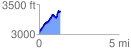
 1.329034 mi
 453.87 ft
 93.98 ft
 359.90 ft
 6.47 %
GPX Downloads: Track Route
![]()
| at: |
Fish Hatchery Area |
show on map
animate
1.329034 mi
453.87 ft
93.98 ft
359.90 ft
6.47 %