| at: |
Forney Community Park |
Data from David Muse
 show on map
 animate
Trail users:


Elevation Profile
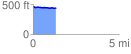
 1.335266 mi
 32.58 ft
 44.49 ft
 -11.91 ft
 0.63 %
GPX Downloads: Track Route
Trailheads:
 Forney Community Park
![]()
| at: |
Forney Community Park |
show on map
animate
1.335266 mi
32.58 ft
44.49 ft
-11.91 ft
0.63 %
Forney Community Park