| at: |
Talty/Crandall Area Roads |
Data from David Muse
 show on map
 animate
Trail users:


Elevation Profile
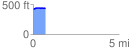
 0.723876 mi
 30.12 ft
 9.35 ft
 20.77 ft
 0.79 %
GPX Downloads: Track Route
![]()
| at: |
Talty/Crandall Area Roads |
show on map
animate
0.723876 mi
30.12 ft
9.35 ft
20.77 ft
0.79 %