| at: |
Talty/Crandall Area Roads |
Data from David Muse
 show on map
 animate
Trail users:


Elevation Profile
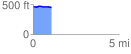
 1.074293 mi
 14.67 ft
 23.92 ft
 -9.25 ft
 0.42 %
GPX Downloads: Track Route
![]()
| at: |
Talty/Crandall Area Roads |
show on map
animate
1.074293 mi
14.67 ft
23.92 ft
-9.25 ft
0.42 %