| at: |
Paynes Creek Recreation Area |
Data from David Muse
 show on map
 animate
Trail users:


Elevation Profile
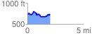
 2.042230 mi
 310.73 ft
 343.41 ft
 -32.68 ft
 3.18 %
GPX Downloads: Track Route
![]()
| at: |
Paynes Creek Recreation Area |
show on map
animate
2.042230 mi
310.73 ft
343.41 ft
-32.68 ft
3.18 %