| at: |
Greenprints |
Data from David Muse
 show on map
 animate
Trail users:


Elevation Profile
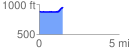
 1.479423 mi
 98.16 ft
 25.16 ft
 73.00 ft
 1.26 %
GPX Downloads: Track Route
Trailheads:
 Downtown Woodstock
![]()
| at: |
Greenprints |
show on map
animate
1.479423 mi
98.16 ft
25.16 ft
73.00 ft
1.26 %
Downtown Woodstock