| at: |
Serenbe |
Data from David Muse
 show on map
 animate
Trail users:


Elevation Profile
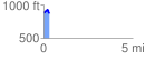
 0.310105 mi
 49.90 ft
 80.15 ft
 -30.25 ft
 4.90 %
GPX Downloads: Track Route
![]()
| at: |
Serenbe |
show on map
animate
0.310105 mi
49.90 ft
80.15 ft
-30.25 ft
4.90 %