| at: |
Serenbe |
Data from David Muse
 show on map
 animate
Trail users:


Elevation Profile
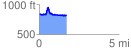
 1.721699 mi
 334.45 ft
 357.02 ft
 -22.57 ft
 3.93 %
GPX Downloads: Track Route
![]()
| at: |
Serenbe |
show on map
animate
1.721699 mi
334.45 ft
357.02 ft
-22.57 ft
3.93 %