| at: |
Serenbe |
Data from David Muse
 show on map
 animate
Trail users:


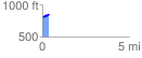
Elevation Profile
 0.380837 mi
 82.05 ft
 33.30 ft
 48.75 ft
 4.08 %
GPX Downloads: Track Route
![]()
| at: |
Serenbe |
show on map
animate
0.380837 mi
82.05 ft
33.30 ft
48.75 ft
4.08 %