|
| at: |
Gaddistown/Canada Creek Cane Creek/Two Run |
Data from David Muse
 show on map
 animate
Trail users:


Elevation Profile
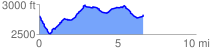
 6.698152 mi
 796.33 ft
 779.28 ft
 17.05 ft
 2.25 %
GPX Downloads: Track Route
![]()
|
| at: |
Gaddistown/Canada Creek Cane Creek/Two Run |
show on map
animate
6.698152 mi
796.33 ft
779.28 ft
17.05 ft
2.25 %