| at: |
Chisenhall Fields |
Data from David Muse
 show on map
 animate
Trail users:


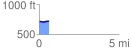
Elevation Profile
 0.600001 mi
 16.27 ft
 10.56 ft
 5.71 ft
 0.51 %
GPX Downloads: Track Route
![]()
| at: |
Chisenhall Fields |
show on map
animate
0.600001 mi
16.27 ft
10.56 ft
5.71 ft
0.51 %