| at: |
Ray Roberts Lake State Park - Isle DeBois Unit |
Data from David Muse
 show on map
 animate
Trail users:


Elevation Profile
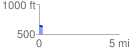
 0.209555 mi
 3.77 ft
 27.10 ft
 -23.33 ft
 2.45 %
GPX Downloads: Track Route
![]()
| at: |
Ray Roberts Lake State Park - Isle DeBois Unit |
show on map
animate
0.209555 mi
3.77 ft
27.10 ft
-23.33 ft
2.45 %