| at: |
Dunnellon Trail |
Data from Karlos Bernart
 show on map
 animate
Trail users:


Elevation Profile
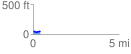
 0.434358 mi
 27.40 ft
 27.40 ft
 0.00 ft
 1.19 %
GPX Downloads: Track Route
![]()
| at: |
Dunnellon Trail |
show on map
animate
0.434358 mi
27.40 ft
27.40 ft
0.00 ft
1.19 %