| at: |
McLendon-Chisholm Area Roads |
Data from David Muse
 show on map
 animate
Trail users:


Elevation Profile
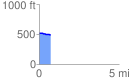
 0.745496 mi
 0.00 ft
 27.30 ft
 -27.30 ft
 0.69 %
GPX Downloads: Track Route
![]()
| at: |
McLendon-Chisholm Area Roads |
show on map
animate
0.745496 mi
0.00 ft
27.30 ft
-27.30 ft
0.69 %