| at: |
McLendon-Chisholm Area Roads |
Data from David Muse
 show on map
 animate
Trail users:


Elevation Profile
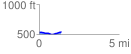
 1.388539 mi
 43.01 ft
 41.14 ft
 1.87 ft
 0.59 %
GPX Downloads: Track Route
![]()
| at: |
McLendon-Chisholm Area Roads |
show on map
animate
1.388539 mi
43.01 ft
41.14 ft
1.87 ft
0.59 %