| at: |
McLendon-Chisholm Area Roads |
Data from David Muse
 show on map
 animate
Trail users:


Elevation Profile
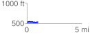
 1.006630 mi
 55.51 ft
 44.06 ft
 11.45 ft
 1.04 %
GPX Downloads: Track Route
![]()
| at: |
McLendon-Chisholm Area Roads |
show on map
animate
1.006630 mi
55.51 ft
44.06 ft
11.45 ft
1.04 %