| at: |
Ray Roberts Greenbelt |
Data from David Muse
 show on map
 animate
Trail users:


Elevation Profile
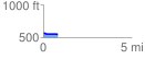
 0.827012 mi
 1.38 ft
 28.38 ft
 -27.00 ft
 0.65 %
GPX Downloads: Track Route
Trailheads:
 Ray Roberts Dam Fishing Lot
![]()
| at: |
Ray Roberts Greenbelt |
show on map
animate
0.827012 mi
1.38 ft
28.38 ft
-27.00 ft
0.65 %
Ray Roberts Dam Fishing Lot