| at: |
Ray Roberts Greenbelt |
Data from David Muse
 show on map
 animate
Trail users:


Elevation Profile
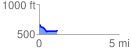
 1.127156 mi
 34.19 ft
 120.14 ft
 -85.96 ft
 2.02 %
GPX Downloads: Track Route
![]()
| at: |
Ray Roberts Greenbelt |
show on map
animate
1.127156 mi
34.19 ft
120.14 ft
-85.96 ft
2.02 %